Tag Archives: earthquakes

The sounds of recent (December 2023) seismic activity in Iceland

On the heels of yesterday’s When the rocks sing “I got rhythm” (my December 18, 2023 posting), I received (via email) a media notice/reminder/update about a Northwestern University (Chicago, Illinois, US) app that allows you to listen,

From the original November 16, 2023 Northwestern University news release by Amanda Morris (also published as a November 16, 2023 news item on phys.org),

As seismic activity intensifies ahead of an impending eruption of a fissure near Iceland’s Fagradalsfjall volcano, the island’s Reykjanes Peninsula is experiencing hundreds of earthquakes per day.

Now, listeners can follow along through Northwestern University’s Earthtunes app. Developed in 2019, the app transforms seismic frequencies into audible pitches. Whereas a classic seismometer records motions in the Earth’s surface as squiggly lines scratched across a page, Earthtunes enables users to hear, rather than see, activity.

So far, Iceland’s recent, ongoing seismic activity sounds like a jarring symphony of doors slamming, hail pelting against a tin roof or window and people cracking trays of ice cubes.

By listening to activities recorded by the Global Seismographic Network station (named BORG), located to the north-northeast of Reykjavik, people can hear how the seismic activity has changed around the Fagradalsfjall area.

In this audio clip, listeners can hear 24 hours of activity recorded from Friday, Nov. 10, into Saturday, Nov. 11. Peppered with a cacophony of sharp knocking noises, it sounds like someone is insistently banging on a door.

“The activity is formidable, exciting and scary,” said Northwestern seismologist Suzan van der Lee, who co-developed Earthtunes. “Iceland did the right thing by evacuating residents in nearby Grindavik and the nearby Svartsengi geothermal power plant, one of the world’s oldest geothermal power plants, which was the first to combine electricity generation with hot water for heating in the region.”

Van der Lee is the Sarah Rebecca Roland Professor of Earth and Planetary Sciences at Northwestern’s Weinberg College of Arts and Sciences. In her research, she applies data science to millions of records of seismic waves in order to decode seismic signals, which harbor valuable information about the Earth’s interior dynamics.

As hundreds of earthquakes shake the ground, Van der Lee says the impending eruption is reminiscent of the 1973 eruption of Heimaey on Iceland’s Vestmannaeyjar archipelago.

“This level of danger is unprecedented for this area of Iceland, but not for Iceland as a whole,” said van der Lee, who hiked Fagradalsfjall in June. “While most Icelandic volcanoes erupt away from towns and other infrastructure, Icelanders share the terrible memory of an eruption 50 years ago on the island Vestmannaeyjar, during which lava covered part of that island’s town, Heimaey. The residents felt very vulnerable, as the evacuated people of Grindavik feel now. In a few days or weeks, they might no longer have their jobs, homes and most possessions, while still having to feed their families and pay their mortgages. However, partially resulting from that eruption on Vestmannaeyjar, Icelanders are well prepared for the current situation in the Fagradallsfjall-Svartsengi-Grindavik area.” 

Accelerated audio

This audio clip presents the same data, with the pitch increased by 10 octaves. Listeners will hear a long, low rumbling sound, punctuated by an occasional slamming door.

“What you’re hearing is 24 hours of seismic data — filled with earthquake signals,” van der Lee said. “The vast majority of these quakes are associated with the magma intrusion into the crust of the Fagradallsfjall-Svartsengi-Grindavik area of the Reykjanes Peninsula. Seismic data are not audible; their frequencies are too low. So, the 24 hours of data are compressed into approximately 1.5 minutes of audio data. You can hear an unprecedented intensity of earthquakes during the night from last Friday into Saturday and related to a new magma intrusion into the crust area.”

In a third audio clip, the same data is less compressed, with the pitch increased by just seven octaves

“One can hear frequent earthquakes happening at this point,” van der Lee said. “Icelandic seismologists have been monitoring these quakes and their increasing vigor and changing patterns. They recognized similar patterns to earthquake swarms that preceded the 2021-2023 eruptions of the adjacent Fagradallsfjall volcano.”

Earthtunes is supported by the American Geophysical Union and Northwestern’s department of Earth and planetary sciences. Seismic data is obtained from the Earthscope Consortium. The app was designed and developed by van der Lee, Helio Tejedor, Melanie Marzen, Igor Eufrasio, Josephine Anderson, Liam Toney, Cooper Barth, Michael Ji and Leonicio Cabrera.

Jennifer Ouellette’s November 16, 2023 article for Ars Tecnica draws heavily from the news release while delving into the topic of data sonification (making sounds from data), Note: Links have been removed,

….

Sonification of scientific data is an area of growing interest in many different fields. For instance, several years ago, a project called LHCSound built a library of the “sounds” of a top quark jet and the Higgs boson, among others. The project hoped to develop sonification as a technique for analyzing the data from particle collisions so that physicists could “detect” subatomic particles by ear. Other scientists have mapped the molecular structure of proteins in spider silk threads onto musical theory to produce the “sound” of silk in hopes of establishing a radical new way to create designer proteins. And there’s a free app for Android called the Amino Acid Synthesizer that enables users to create their own protein “compositions” from the sounds of amino acids.

The December 19, 2023 Northwestern University media update points to the latest audio file of the eruption of the svartsengi-grindavik fissure in Iceland: 24 hours as of Monday, December 18, 2023 14:00:00 UTC.

Enjoy!

One last thing, there are a number of postings about data sonification here; many but not all scientists and/or communication practitioners think to include audio files.
What do nanocrystals have in common with the earth’s crust?

The deformation properties of nanocrystals resemble those in the earth’s crust according to a Nov. 17, 2015 news item on Nanowerk,

Apparently, size doesn’t always matter. An extensive study by an interdisciplinary research group suggests that the deformation properties of nanocrystals are not much different from those of the Earth’s crust.

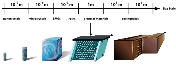
“When solid materials such as nanocrystals, bulk metallic glasses, rocks, or granular materials are slowly deformed by compression or shear, they slip intermittently with slip-avalanches similar to earthquakes,” explained Karin Dahmen, a professor of physics at the University of Illinois at Urbana-Champaign. “Typically these systems are studied separately. But we found that the scaling behavior of their slip statistics agree across a surprisingly wide range of different length scales and material structures.”

There’s an illustration accompanying the research,

Courtesy of the University of Illinois

Caption: When solid materials such as nanocrystals, bulk metallic glasses, rocks, or granular materials are slowly deformed by compression or shear, they slip intermittently with slip-avalanches similar to earthquakes. Credit: University of Illinois

A Nov. 17, 2015 University of Illinois news release (also on EurekAlert) by Rick Kubetz, which originated the news item, provides more detail,

“Identifying agreement in aspects of the slip statistics is important, because it enables us to transfer results from one scale to another, from one material to another, from one stress to another, or from one strain rate to another,” stated Shivesh Pathak, a physics undergraduate at Illinois, and a co-author of the paper, “Universal Quake Statistics: From Compressed Nanocrystals to Earthquakes,” appearing in Scientific Reports. “The study shows how to identify and explain commonalities in the deformation mechanisms of different materials on different scales.

“The results provide new tools and methods to use the slip statistics to predict future materials deformation,” added Michael LeBlanc, a physics graduate student and co-author of the paper. “They also clarify which system parameters significantly affect the deformation behavior on long length scales. We expect the results to be useful for applications in materials testing, failure prediction, and hazard prevention.”

Researchers representing a broad a range of disciplines–including physics, geosciences, mechanical engineering, chemical engineering, and materials science–from the United States, Germany, and the Netherlands contributed to the study, comparing five different experimental systems, on several different scales, with model predictions.

As a solid is sheared, each weak spot is stuck until the local shear stress exceeds a random failure threshold. It then slips by a random amount until it re-sticks. The released stress is redistributed to all other weak spots. Thus, a slipping weak spot can trigger other spots to fail in a slip avalanche.

Using tools from the theory of phase transitions, such as the renormalization group, one can show that the slip statistics of the model do not depend on the details of the system.

“Although these systems span 13 decades in length scale, they all show the same scaling behavior for their slip size distributions and other statistical properties,” stated Pathak. “Their size distributions follow the same simple (power law) function, multiplied with the same exponential cutoff.”

The cutoff, which is the largest slip or earthquake size, grows with applied force for materials spanning length scales from nanometers to kilometers. The dependence of the size of the largest slip or quake on stress reflects “tuned critical” behavior, rather than so-called self-organized criticality, which would imply stress-independence.

“The agreement of the scaling properties of the slip statistics across scales does not imply the predictability of individual slips or earthquakes,” LeBlanc said. “Rather, it implies that we can predict the scaling behavior of average properties of the slip statistics and the probability of slips of a certain size, including their dependence on stress and strain-rate.”

Here’s a link to and a citation for the paper,

Universal Quake Statistics: From Compressed Nanocrystals to Earthquakes by Jonathan T. Uhl, Shivesh Pathak, Danijel Schorlemmer, Xin Liu, Ryan Swindeman, Braden A. W. Brinkman, Michael LeBlanc, Georgios Tsekenis, Nir Friedman, Robert Behringer, Dmitry Denisov, Peter Schall, Xiaojun Gu, Wendelin J. Wright, Todd Hufnagel, Andrew Jennings, Julia R. Greer, P. K. Liaw, Thorsten Becker, Georg Dresen, & Karin A. Dahmen.  Scientific Reports 5, Article number: 16493 (2015)  doi:10.1038/srep16493 Published online: 17 November 2015

This is an open access paper.

One final comment, this story reminds me of a few other pieces of research featured here, which focus on repeating patterns in nature. The research was mentioned in an Aug. 27, 2015 posting about white dwarf stars and heartbeats and in an April 14, 2015 posting about gold nanoparticles and their resemblance to the Milky Way. You can also find more in the Wikipedia entry titled ‘Patterns in nature‘.

STEM for refugees and disaster relief

Just hours prior to the terrorist bombings in Paris (Friday, Nov. 13, 2015), Tash Reith-Banks published a Nov. 13, 2015 essay (one of a series) in the Guardian about science, technology, engineering, and mathematics (STEM) as those specialties apply to humanitarian aid with a special emphasis on Syrian refugee crisis.

This first essay focuses on how engineering and mathematics are essential when dealing with crises (from Reith-Banks’s Nov. 13, 2015 essay), Note: Links have been removed,

Engineering is a clear starting point: sanitation, shelter and supply lines are all essential in any crisis. As Martin McCann, CEO at RedR, which trains humanitarian NGO workers says: “There is the obvious work in providing water and sanitation and shelter. By shelter, we mean not only shelter or housing for disaster-affected people or refugees, but also structures to store both food and non-food items. Access is always critical, so once again engineers are needed to build roads or in some cases temporary landing strips.”

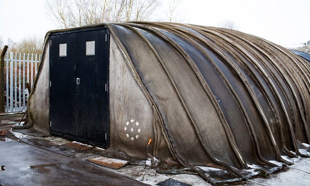
Emergency structures need to be light and fast to transport and erect, but tend not to be durable. One recent development comes from engineers Peter Brewin and Will Crawford of Concrete Canvas., The pair have developed a rapid-setting concrete-impregnated fabric that requires only air and water to harden into a water-proof, fire-resistant construction. This has been used to create rapidly deployable concrete shelters that can be carried in a bag and set up in an hour.

Here’s what one of the concrete shelters looks like,

A Concrete Canvas shelter. Once erected the structure takes 24 hours to harden, and then can be further insulated with earth or snow if necessary. Photograph: Gareth Phillips/Gareth Phillips for the Guardian

A Concrete Canvas shelter. Once erected the structure takes 24 hours to harden, and then can be further insulated with earth or snow if necessary. Photograph: Gareth Phillips/Gareth Phillips for the Guardian

There are many kinds of crises which can lead to a loss of shelter, access to water and food, and diminished safety and health as Reith-Banks also notes in a passage featuring mathematics (Note: A link has been removed),

Maths might seem a far cry from the sort of practical innovation described above, but of course it’s the root of great logistics. Alistair Clark from the University of the West of England is using advanced mathematical modelling to improve humanitarian supply chains to ensure aid is sent exactly where it is needed. Part of the Newton Mobility scheme, Clark’s project will partner with Brazilian disaster relief agencies and develop ways of modelling everything from landslides to torrential downpours in order to create sophisticated humanitarian supply chains that can rapidly adapt to a range of possible disaster scenarios and changing circumstances.

In a similar vein, Professor Amr Elnashai, founder and co-editor of the Journal of Earthquake Engineering, works in earthquake-hit areas to plan humanitarian relief for future earthquakes. He recently headed a large research and development effort funded by the Federal Emergency Management Agency in the USA (FEMA), to develop a computer model of the impact of earthquakes on the central eight states in the USA. This included social impact, temporary housing allocation, disaster relief, medical and educational care, as well as engineering damage and its economic impact.

Reith-Banks also references nanotechnology (Note: A link has been removed),

… Up to 115 people die every hour in Africa from diseases linked to contaminated drinking water and poor sanitation, particularly in the wake of conflicts and environmental disasters. Dr Askwar Hilonga recently won the Royal Academy of Engineering Africa Prize, which is dedicated to African inventions with the potential to bring major social and economic benefits to the continent. Hilonga has invented a low cost, sand-based water filter. The filter combines nanotechnology with traditional sand-filtering methods to provide safe drinking water without expensive treatment facilities.  …

Dr. Hilonga who is based in Tanzania was featured here in a June 16, 2015 posting about the Royal Academy of Engineering Prize, his research, and his entrepreneurial efforts.

Reith-Banks’s* essay provides a valuable and unexpected perspective on the humanitarian crises which afflict this planet *and I’m looking forward to the rest of the series*.

*’Reith-Banks’s’ replaced ‘This’ and ‘and I’m looking forward to the rest of the series’ was added Nov. 17, 2015 at 1620 hours PST.

PrepareAthon and ShakeOut! Get ready for disaster

PrepareAthon

A Sept. 28, 2015 “prepareathon” notice came courtesy of the US Geological Survey (USGS). While this particular programme is US-centric (their ShakeOut mentioned later in this post is international in scope), sign-up or registration is not required and there is good general information about how to prepare and what to do in a variety of disaster-scenarios on the Hazards page of their website.  For those who can participate, here’s more,

Science Feature: Join America’s PrepareAthon!
Practice what to do in the event of a disaster or emergency.

Join millions of people participating in America’s PrepareAthon! on Sept. 30. This campaign encourages the nation to conduct drills, discussions and exercises to practice what to do before, during and after a disaster or emergency strikes.

The campaign will focus on preparing for floods, wildfires, hurricanes and power outages. Each year, the campaign holds two national days of action, with each day highlighting different hazards. This is the second national day of action this year.

Start with Science

USGS science is essential to understanding a wide range of hazards—including volcanoes, landslides, wildlife health and many others beyond this specific campaign—and provides a basis on which preparedness actions are developed.

USGS real-time monitoring of the nation’s rivers and streams provides officials with critical information for flood warnings, forecasts and evacuation warnings.

Before, during and after wildfire disasters, the USGS provides tools to identify wildfire risks and reduce subsequent hazards, such as landslides. USGS scientists also provide real-time maps and satellite imagery to firefighters.

For major storms or hurricanes, USGS science helps forecast the likelihood of coastal impacts. The USGS also measures storm surge and monitors water levels of inland rivers and streams.

Power outages can have many causes, including geomagnetic storms that result from the dynamic interaction of solar wind and the Earth’s magnetic field. The USGS operates a unique network of observatories that provide real-time data on magnetic storm conditions.

Coordination and Community

America’s PrepareAthon! is part of President Obama’s Presidential Policy Directive 8: National Preparedness and led by The Federal Emergency Management Agency (FEMA). The USGS is one of many supporting and contributing agencies. This campaign is coordinated with federal, state, local, tribal and territorial governments, the private sector and non-governmental organizations.

ShakeOut

The same Sept. 28, 2015 USGS notice includes some information about a “ShakeOut” (of particular interest to someone who lives in what’s known as the Ring of Fire or less colourfully as the circum-Pacific Belt earthquake/volcanic zone [Wikipedia entry]). This is an international (Japan, Italy, Canada, and others in addition to the US) event,

Get Ready to ShakeOut on October 15

Sign up for the next Great ShakeOut earthquake drill on October 15, 2015, and practice “drop, cover, and hold on,” the recommended safety action to take during an earthquake.

You can check out your state, province, or country, as I did for British Columbia (Canada). Here’s what I found,

On October 15* [2015], officially “ShakeOut BC Day,” millions of people worldwide will practice how to Drop, Cover, and Hold On at 10:15 a.m. during Great ShakeOut Earthquake Drills!

British Columbians can join by registering for the 2015 Great British Columbia ShakeOut.

The page hosts an embedded video and it’s available en français. It also offers these statistics: 610,000 have already signed up the 2015 event; last year (2014), there were over 740,000 participants.

Earthquakes, deep and shallow, and their nanocrystals

Those of us who live in this region are warned on a regular basis that a ‘big’ one is overdue somewhere along the West Coast of Canada and the US. It gives me an interest in the geological side of things  While the May 19, 2015 news items on Azonano featuring the research story as told by the University of Oklahoma and the University of California at Riverside doesn’t fall directly under my purview, it’s close enough.

Here’s the lead researcher, Harry W. Green II, from the University of California at Riverside explaining, the work,

The May 18, 2015 University of Oklahoma news release on EurekAlert offers a succinct summary,

A University of Oklahoma structural geologist and collaborators are studying earthquake instability and the mechanisms associated with fault weakening during slip. The mechanism of this weakening is central to understanding earthquake sliding.

Ze’ev Reches, professor in the OU School of Geology and Geophysics, is using electron microscopy to examine velocity and temperature in two key observations: (1) a high-speed friction experiment on carbonate at conditions of shallow earthquakes, and (2) a high-pressure/high-temperature faulting experiment at conditions of very deep earthquakes.

Reches and his collaborators have shown phase transformation and the formation of nano-size (millionth of a millimeter) grains are associated with profound weakening and that fluid is not necessary for such weakening. If this mechanism operates in major earthquakes, it resolves two major conflicts between laboratory results and natural faulting–lack of a thermal zone around major faults and the rarity of glassy rocks along faults.

The May 18, 2015 University of California at Riverside (UCR) news release provides more detail about earthquakes,

Earthquakes are labeled “shallow” if they occur at less than 50 kilometers depth.  They are labeled “deep” if they occur at 300-700 kilometers depth.  When slippage occurs during these earthquakes, the faults weaken.  How this fault weakening takes place is central to understanding earthquake sliding.

A new study published online in Nature Geoscience today by a research team led by University of California, Riverside geologists now reports that a universal sliding mechanism operates for earthquakes of all depths – from the deep ones all the way up to the crustal ones.

“Although shallow earthquakes – the kind that threaten California – must initiate differently from the very deep ones, our new work shows that, once started, they both slide by the same physics,” said deep-earthquake expert Harry W. Green II, a distinguished professor of the Graduate Division in UC Riverside’s Department of Earth Sciences, who led the research project. “Our research paper presents a new, unifying model of how earthquakes work. Our results provide a more accurate understanding of what happens during earthquake sliding that can lead to better computer models and could lead to better predictions of seismic shaking danger.”

The UCR news release goes on to describe the physics of sliding and a controversy concerning shallow and deep earthquakes,

The physics of the sliding is the self-lubrication of the earthquake fault by flow of a new material consisting of tiny new crystals, the study reports. Both shallow earthquakes and deep ones involve phase transformations of rocks that produce tiny crystals of new phases on which sliding occurs.

“Other researchers have suggested that fluids are present in the fault zones or generated there,” Green said. “Our study shows fluids are not necessary for fault weakening. As earthquakes get started, local extreme heating takes place in the fault zone. The result of that heating in shallow earthquakes is to initiate reactions like the ones that take place in deep earthquakes so they both end up lubricated in the same way.”

Green explained that at 300-700 kilometers depth, the pressure and temperature are so high that rocks in this deep interior of the planet cannot break by the brittle processes seen on Earth’s surface. In the case of shallow earthquakes, stresses on the fault increase slowly in response to slow movement of tectonic plates, with sliding beginning when these stresses exceed static friction. While deep earthquakes also get started in response to increasing stresses, the rocks there flow rather than break, except under special conditions.

“Those special conditions of temperature and pressure induce minerals in the rock to break down to other minerals, and in the process of this phase transformation a fault can form and suddenly move, radiating the shaking – just like at shallow depths,” Green said.

The research explains why large faults like the San Andreas Fault in California do not have a heat-flow anomaly around them. Were shallow earthquakes to slide by the grinding and crunching of rock, as geologists once imagined, the process would generate enough heat so that major faults like the San Andreas would be a little warmer along their length than they would be otherwise.

“But such a predicted warm region along such faults has never been found,” Green said.  “The logical conclusion is that the fault must move more easily than we thought.  Extreme heating in a very thin zone along the fault produces the very weak lubricant.  The volume of material that is heated is very small and survives for a very short time – seconds, perhaps – followed by very little heat generation during sliding because the lubricant is very weak.”

The new research also explains why faults with glass on them (reflecting the fact that during the earthquake the fault zone melted) are rare. As shallow earthquakes start, the temperature rises locally until it is hot enough to start a chemical reaction – usually the breakdown of clays or carbonates or other hydrous phases in the fault zone.  The reactions that break down the clays or carbonates stop the temperature from climbing higher, with heat being used up in the reactions that produce the nanocrystalline lubricant.

If the fault zone does not have hydrous phases or carbonates, the sudden heating that begins when sliding starts raises the local temperature on the fault all the way to the melting temperature of the rock.  In such cases, the melt behaves like a lubricant and the sliding surface ends up covered with melt (that would quench to a glass) instead of the nanocrystalline lubricant.

“The reason this does not happen often, that is, the reason we do not see lots of faults with glass on them, is that the Earth’s crust is made up to a large degree of hydrous and carbonate phases, and even the rocks that don’t have such phases usually have feldspars that get crushed up in the fault zone,” Green explained. “The feldspars will ‘rot’ to clays during the hundred years or so between earthquakes as water moves along the fault zone. In that case, when the next earthquake comes, the fault zone is ready with clays and other phases that can break down, and the process repeats itself.”

The research involved the study of laboratory earthquakes – high-pressure earthquakes as well as high-speed ones – using electron microscopy in friction and faulting experiments. It was Green’s laboratory that first conducted a serendipitous series of experiments, in 1989, on the right kind of mantle rocks that give geologists insight into how deep earthquakes work. In the new work, Green and his team also investigated the Punchbowl Fault, an ancestral branch of the San Andreas Fault that has been exhumed by erosion from several kilometers depth, and found nanometric materials within the fault – as predicted by their model.

Here’s a link to and a citation for the paper,

Phase transformation and nanometric flow cause extreme weakening during fault slip by H. W. Green II, F. Shi, K. Bozhilov, G. Xia, & Z. Reches. Nature Geoscience (2015) doi:10.1038/ngeo2436 Published online 18 May 2015

This paper is behind a paywall.

The next megathrust earthquake at Vancouver’s (Canada) August 26, 2014 Café Scientifique

Vancouver’s next Café Scientifique is being held in the back room of the The Railway Club (2nd floor of 579 Dunsmuir St. [at Seymour St.], Vancouver, Canada), on Tuesday, August 26,  2014 at 7:30 pm. Here’s the meeting description (from the August 19, 2014 announcement),

Our speaker for the evening will be Dr. Carlos Ventura,the Director of the Earthquake Engineering Research Facility (EERF) at the University of British Columbia.  The title of his talk is:

A Megathrust Earthquake in the West Coast – The clock is ticking

The theme of the talk is about the effects of megathrust earthquakes in the last ten years in the built environment, and the lessons that we have learned from them.  These are helping us understand better what would be the possible effects of the “big one” on the West Coast of BC.  Some of the research that we are doing at UBC to better understand the effects of this type of earthquake will be discussed.

From Dr. Carlos Ventura’s UBC Faculty webpage,

Dr. Carlos Ventura is currently the Director of the Earthquake Engineering Research Facility (EERF) at UBC and has more than 30 years of experience as a structural engineer.  Dr. Ventura’s areas of research are in Structural Dynamics and Earthquake Engineering. He has been conducting research on the dynamic behavior and analysis of structural systems subjected to extreme dynamic loads, including severe ground shaking for more than twenty years. His research work includes experimental studies in the field and in the laboratory of structural systems and components.   Research developments have included development and implementation of performance-based design methods for seismic retrofit of low rise school buildings, novel techniques for regional estimation of damage to structures during earthquakes, detailed studies on nonlinear dynamic analysis of structures and methods to evaluate the dynamic characteristics of large Civil Engineering structures. …

You can find out more about the Earthquake Engineering Research Facility (EERF) here.